Home

Introduction

A map of Australia showing four regions of cyclones. Region A is designated as normal and applies to most of the interior of Australia including Tasmania. Region B is Intermediate and applies to a narrow band of the coast from just north of Perth up the west coast to just south of Carnarvon. Region B then starts again a little inland halfway between Port Hedland and Broome and continues north inland through Darwin and Cairns to Bundaberg. From there region B becomes coastal again down to Coffs Harbour. Region C is tropical cyclones and starts a little inland near Carnarvon on the west coast at and is a narrow band through Darwin and around to Bundaberg on the east coast. Region D is a narrow coastal band from Carnarvon to halfway between Port Hedland and Broome.

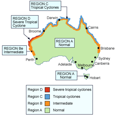
The BCA and related Australian Standards provide clear guidelines for the construction of buildings within the following wind regions:

  • Region A - Normal
  • Region B - Intermediate
  • Region C - Tropical cyclones
  • Region D - Severe tropical cyclones.

Note that high wind areas exist outside the cyclonic regions indicated on the map. High wind areas are regions that have design wind speeds which are calculated in accordance with AS 1170.2.

Refer to the BCA, Table 1.1.1 Design wind speed - equivalent values for more information.